

Listen to this article
Listen time 4 min 18 s
Show the transcript
You have opened ACTmapi, found your block and seen a neat line around it. Now you want to use that line: for a new fence, a carport close to the side boundary, a retaining wall, or to check what a neighbour is saying.
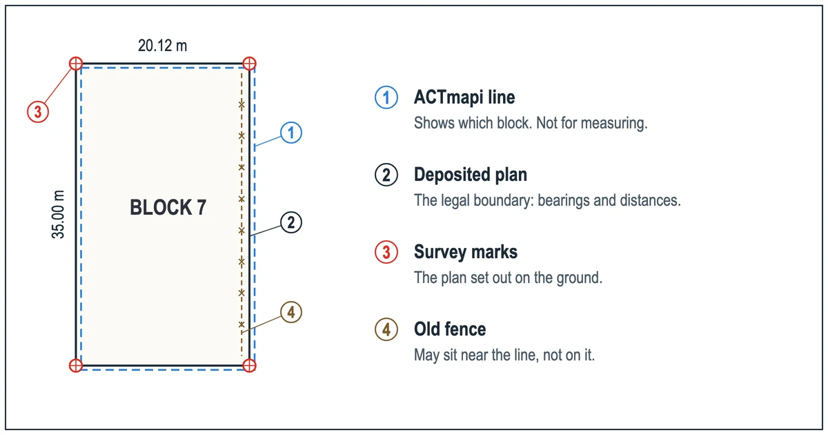
The short answer is that ACTmapi tells you which block is yours and what applies to it. It is not the record of where the boundary sits on the ground. That record is the deposited plan, and the marks a registered surveyor places from it. This guide shows what each of the three tells you, how to get the plan yourself, and when it is worth having the boundary marked.
General information only, not legal advice. Fees and pages checked 10 November 2026.
Does ACTmapi show your exact boundary? The short answer
No, and it does not claim to. The ACT Government describes ACTmapi's material as "a general reference source" and asks users to check its accuracy and get professional advice before relying on it in any important matter (ACTmapi disclaimer). The Territory's own description of its block data adds that "block boundaries may not always align exactly" and that "the legal definition of a block is defined in the Deposited plan" (ACT Government block dataset).
So the map line is a good picture of your block. The deposited plan is the definition. Marks placed by a registered surveyor put that definition on the ground.
Key takeaways
- Use ACTmapi to find your block and section and its zoning.
- The legal boundary is defined by the deposited plan. Through ACTLIS it costs $26, after a $36 title search if you need the plan number (fees at 1 July 2026).
- Only a surveyor registered under the Surveyors Act 2007 (ACT) can survey and mark your boundary.
- Before a fence, wall or extension near the line, have the boundary marked rather than measuring from a screen.
What ACTmapi is good for
ACTmapi is the right place to start. The ACT Government points owners to the ACTmapi 'Basic Map' to find their block and section numbers, the zoning of the block and the types of development allowed, with the development controls themselves in the Territory Plan (ACT Government, understanding your block).
That makes it useful for questions like these:
- Which block and section is this house on?
- What zone is the block in, and which development controls might apply?
For both of those, the map is enough, and you do not need a survey to answer them.
What ACTmapi was not built for
The trouble starts when a line on screen is used as a measurement. A fencer setting posts, a builder setting out a slab near a side boundary, or an owner pacing out a retaining wall all need the boundary's exact position on the ground. Neither ACTmapi's disclaimer nor the block data note offers the map for that: the disclaimer points users to professional advice, and the block data note points to the deposited plan.
Two things make the difference matter more than it looks:
- Planning controls apply to your block. Development controls in the Territory Plan apply to your block (ACT Government, understanding your block). Working out where new work sits against them starts with knowing where the boundary is.
- Services sit near boundaries. The ACT Government warns that if you build over or too close to utility assets, you can be liable to remove the obstruction or pay to move the mains (ACT Government, understanding your block).
An old fence is not a better guide. It may have been built to the line, or near it, decades ago.
The records that show where the line is
Two records decide where your boundary is: the deposited plan and the survey marks.
The deposited plan. A registered block appears on a deposited plan registered with the Land Titles Office, and the legal definition of the block is in that plan (ACT Government block dataset). Deposited plans are among the plans surveyors use as the origin of the marks used to redefine a boundary (ACT Government, cadastral plans and data).
You can buy it yourself through ACTLIS, the ACT Land Information System, as a member of the public (Access Canberra). A plan search needs the plan number. If you do not have it, start with a title search by street address: it gives you the plan number and a link to the plan. Access Canberra's fees, current as at 1 July 2026, are below (Access Canberra land title fees).
| Search | What it gives you | Fee |
|---|---|---|
| Certificate of title search | Registered owner and interests, and the plan number with a link | $36.00 |
| Deposited plan search | The registered plan with your block's dimensions | $26.00 |
| Crown lease search | Your Crown lease and its terms | $36.00 |
| Instrument or dealing search | A registered document named on the title | $24.00 |
Access Canberra links to an official ACT Government walkthrough of ACTLIS for public users:
The survey marks. The plan is a set of measurements. Marks placed by a registered surveyor are those measurements on the ground. The ACT Government is plain about who can do this: "You can't survey a boundary yourself. Only surveyors can do this for you, as long as they're registered under the Surveyors Act 2007" (ACT Government, survey a boundary).
Building or fencing near the line?
Tell us the address and what you are planning. We will tell you, free, whether you need the boundary marked and what the survey would involve.
Which record suits which job
| Your job | Start with | What settles it |
|---|---|---|
| Find your block, section and zone | ACTmapi | ACTmapi is enough |
| Check the block's dimensions before buying | ACTmapi, then the deposited plan | The deposited plan |
| Replace or build a fence on the boundary | The deposited plan | A boundary survey with the line marked |
| Build or extend near a side or rear boundary | The plan and the Territory Plan controls | Boundary marks, then a set-out survey for the work |
| Brief a designer for new plans | The plan | A contour and detail survey |
| A neighbour disagrees about the line | The plan | A boundary survey; the legal side is for a solicitor |
A marked boundary gives you, your neighbour and your fencer or builder the same measured starting point.
From a line on screen to marks on the ground
A boundary survey shows where the legal boundaries of your block sit on the ground and how nearby fences or buildings relate to them. The surveyor gathers the registered plans and older survey records for the block, works out where the boundaries should fall, finds and measures existing survey marks on site, and, where your quote includes marking, marks the boundary so you can fence or build to it. Where records and site measurements do not agree, the differences should be noted on the plan or in a report with it. Depending on the job you receive a plan of the boundary and nearby structures, or a survey certificate for a development application.
To get a quote, send:
- the address, and the block and section if you have them;
- what you are planning (fence, extension, carport, wall) and where on the block;
- your deposited plan or title search if you have bought one;
- any deadline, such as a fencer's start date or a settlement date.
Prices depend on the block and the job; our guide to land survey costs in Canberra sets out the published prices and what moves them.
One rule matters once marks are in. Disturbing a survey mark is an offence under section 53 of the Surveyors Act 2007, except where it is removed to put up a fence or do construction work on or near the boundary, or there is another reasonable excuse (Surveyors Act 2007, s 53; ACT Government, survey marks). If a peg is in the way of something else, ask the surveyor before moving it.
We work across Canberra and the ACT, with over 9 years' experience. Call (02) 5114 2569 or use the contact form.
ACTmapi and boundary questions Canberra owners ask
Is the ACTmapi block line the legal boundary?
No. ACTmapi describes its material as a general reference source (ACTmapi disclaimer), and the ACT Government's block data notes that block boundaries may not always align exactly and that the legal definition of a block is in the deposited plan (ACT Government block dataset).
How do I get my deposited plan in the ACT?
Use ACTLIS. Search the title by street address to get the plan number and a link, then buy the deposited plan search (Access Canberra, search the register). The plan search is $26.00 and the title search $36.00 as at 1 July 2026 (Access Canberra land title fees).
Can I mark my own boundary from the plan?
No. The ACT Government says you cannot survey a boundary yourself; only surveyors registered under the Surveyors Act 2007 can (ACT Government, survey a boundary).
Can I pull out an old survey peg?
Only for the reasons the law allows. Disturbing a survey mark is an offence, but the Surveyors Act 2007 allows removal to put up a fence or do construction work on or near the boundary, or with another reasonable excuse (Surveyors Act 2007, s 53).
Do I need a survey before a new fence?
Yes, if the fence is going on the boundary and there is any doubt about where it runs. The ACT Government lists replacing or building a fence as a reason to have a boundary surveyed (ACT Government, survey a boundary). A boundary survey with the line marked gives you and your neighbour the same starting point.
Know where your boundary is before you build
Free advice and an estimate for boundary surveys across Canberra and the ACT.